


The History of Ordnance Survey
Ordnance Survey officially began on 21 June 1791. Its first map, of Kent, was published in 1801 due to the area's vulnerability to French invasion. Surveyed over three years at two inches to one mile (later reduced to one inch), OS started as a military organisation based at the Tower of London, focused on mapping Great Britain.
Early surveyors worked without modern technology, using a baseline laid at what is now Heathrow Airport to begin national triangulation. William Roy, regarded as the founder of OS, led early mapping efforts, with William Mudge later overseeing publication of the first map.
As OS developed, surveyors improved techniques, introducing benchmarks and national height systems. Key milestones included geodetic levelling in 1840, the establishment of Ordnance Datum Newlyn in 1921, and the creation of trig pillars from 1936, used to map the country with precision.
OS also tackled unique challenges, such as confirming Ben Nevis as Britain’s highest peak and recording rare alignments of magnetic, grid, and true north.
As OS developed, surveyors refined their methods, using benchmarks to track height changes nationwide. Geodetic levelling began in Liverpool in 1840, later leading to the establishment of Ordnance Datum Newlyn in 1921, which still defines Britain’s height measurements today.
In 1936, OS introduced trig pillars, starting at Cold Ashby, to re-triangulate the country; thousands remain visible on hills and moors. Beyond mapping, OS confirmed Ben Nevis as Britain’s highest peak and recorded rare alignments of magnetic, grid, and true north.
OS continues to innovate while maintaining its heritage, with today’s OS Maps routes tracing back to the earliest recorded walking paths.
The Prizes
Ten winners will recieve one of the following prizes:
- OS Mirror Compass
- OS Towel
- OS Walking Poles
- OS Map Case
- OS Maps Gift Card
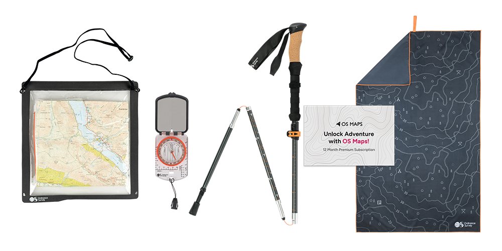
For full T&Cs, please see below.
Specific Terms and Conditions for Ordnance Survey’s 235th Birthday Prize Draw
These Terms
1. These terms and conditions are the Specific Terms which apply to this prize draw promotion (the ‘Prize Draw’).
2. These terms apply in addition to the General Terms and you should read these Specific Terms together with the General Terms, which can be found on the OS website: General Terms and Conditions for Prize Draws (ordnancesurvey.co.uk). If any provisions in these Specific Terms conflict with the General Terms, the Specific Terms shall prevail.
3. By entering this Prize Draw, you accept that you will be bound by these Specific Terms and the General Terms.
The Prize Draw
4. OS is running the Prize Draw (the ‘Promoter’). You can find out more details about the Promoter below.
5. There will be ten winners who will receive one of the prizes at random as stated below:
a. OS Mirror Compass
b. OS Towel
c. OS Walking Poles
d. OS Map Case
e. OS Maps Gift Card
The prize will be provided by Ordnance Survey (the ‘Prize Provider’)
6. The opening date for the Prize Draw is 9am on 16.06.2026.
7. The closing date for the Prize Draw is 11.59pm on 21.06.2026. Entries received after this time will not be counted.
8. The winner will be chosen by OS by random draw from all the valid entries. The draw will take place within 7 days of the closing date.
Entry
9. To enter, you must:
Complete the survey: Celebrating Ordnance Survey's 235th Birthday of Mapping Great Britain – Fill in form
Answer the question, "What do you love about Ordnance Survey?". Enter your name and email. Signing up to recieve marketing emails is optional.
10. No purchase of any product is necessary to enter this prize draw.
11. The Prize Draw is limited to one entry per person.
Winning
12. Failure to claim the prize in accordance with the General Terms will result in the prize being forfeited and OS reserves the right to pick another winner at random from the remaining entries.
13. The Promoter will send the prize free of charge to a UK address provided by the winner within 30 days of the winner claiming their prize. The winner’s details will be passed to the Prize Provider who will send their prize directly to the winner.
14. Instructions on how to activate the annual subscription to OS Maps will be provided by OS. Use of the OS Maps services is subject to separate terms and conditions. These can be found at: www.ordnancesurvey.co.uk/legal/os-maps-terms.
Personal Data
15. Where you have indicated your consent to receiving communications from the Promoter about their offers, products, special offers, promotions and services:
a. your email address will be added to their electronic mailing lists accordingly;
b. any personal data you provide will be processed in accordance with the General Data Protection Regulation (GDPR) and the Data Protection Act 2018 and associated laws;
c. the way in which your data will be processed by OS will be in accordance with OS’ Privacy Policy;
d. see also Condition 31 of the General Terms with regard to the announcement of winners;
e. if you do not wish the use of your details for marketing purposes to continue at any time, you can select the unsubscribe option in the emails that are sent to you.
Promoter
Ordnance Survey Limited (company number 09121572) trading as Ordnance Survey or OS, registered in England and Wales, whose registered office is at Explorer House, Adanac Drive, SOUTHAMPTON SO16 0AS.
Ordnance Survey Leisure Limited is a subsidiary company of Ordnance Survey, which is registered in England and Wales (company no. 06894550), and whose registered office is at Explorer House, Adanac Drive, Southampton SO16 0AS